
- the Ngarri-djarrang (Central Creek) example
Brian Bainbridge March 2009
Summary and introductory information
The State significant Ngarri-djarrang[1] Grassland Reserve covers approximately nine hectares of remnant volcanic plain grassland[2] to the east of Central Creek, a tributary of Merri Creek in the northern Melbourne suburb of Reservoir, Victoria, Australia. Threatened by weed invasion, adhoc biomass reduction and uncontrolled access, restorationof this site has been an ongoing commitment of the Merri Creek Management Committee (MCMC) since 1993.
Stakeholders & budget
Since 1993 MCMC has been funded by Darebin City Council, the formal managers of the Grassland Reserve and a member body of MCMC, to carry out restoration and maintenance of core vegetation at the site. Grants from regional, state and federal sources have funded projects to improve degraded sections of the Reserve. A residential developer funded substantial planning and fencing in early the early 2000s. Works and community engagement expenditure has varied since 1993. During 2006-2008 MCMC expenditure totaled $111,000 with 48% sourced from grants.
Ecosystem and impacts
Ngarri-djarrang lies towards the eastern edge of the 2.3 million hectare Victorian Volcanic Plain Bioregion, an area originally covered by a mosaic of Plains Grassland, Plains Grassy Wetland and other communities associated with the quaternary basalt plains.
The Plains Grasslands, dominated by Kangaroo Grass (Themeda triandra), were diverse, containing numerous small grassy and herbaceous inter-tussock species. Over 120 indigenous species have been recorded from the relatively depauperate Ngarri-djarrang.
The Wurundjeri-willam, the traditional people of the Merri Merri[3], hunted Eastern Grey Kangaroo, Emu and a range of smaller macropods on the extensive plains. The Yam Daisy (Microseris spp.) was a staple food plant harvested using hardened digging sticks (‘kannan’). Fire was extensively used to keep conditions suitable for game and the growth of the food plants. The frequent burning and cultivation of the ground over tens of thousands of years influenced the composition and dynamics of this ecosystem.
Impacts on site
Like other Native Grasslands in Victoria, Ngarri-djarrang was subjected to intensive grazing by sheep following the influx of non-indigenous people in the 1830s. The profound disruption of the traditional Wurundjeri way of life ended Aboriginal practices such as burning. The composition of Victoria’s Native Grasslands shifted rapidly to a dominance of grazing tolerant plants and a reduction in grazing intolerant species such as the Yam Daisy (Microseris spp.), which is now very rare. Overall diversity diminished.
Exotic plant introductions have had an ongoing impact on vegetation quality. Competitive exotic plants became established in many ecological niches preventing re-establishment, especially of disturbance dependant species.
Extinctions in the fauna resulted from habitat change, intensified hunting by non-indigenous humans, introduced predators, competitors and diseases.
Fire continued as an adhoc presence in the landscape through wildfires and some agricultural practices.
Development of the land surrounding Ngarri-djarrang for housing began in the 1950s, leading to complete destruction of any remaining remnant grassland. A local road bisected the site in the 1960’s and a ditch was excavated across the northern part in the 1970s.
Ngarri-djarrang itself was, ironically, spared from housing development because the land formed part of a reservation for a future freeway.
The high value of the remnant grassland was first described in 1990[4] not long before the freeway proposal was abandoned. A ten year campaign to secure the site saw a significant portion protected although some areas were lost to housing[5][6], including the last direct link of open space to the extensive habitat corridor of the Merri Creek parklands 50 metres to the west.
The final major alienation of six hectares of land for housing in 2000 resulted in boundary fencing and interfaces designed specifically to protect and enhance the values of the remaining nine hectares. However, the development inevitably intensified the impacts of urbanisation and isolation on the remaining Grassland Reserve area.
A decline in the vegetation quality of the main Plains Grassy Wetland area is suspected, in part, to be a result of removal of overland flow that occurred as a part of the development of adjoining housing. (See lobbying for protection images on page 8)
Restoration goals and planning
When management works began in 1993, the implicit overall goal was to prevent any further degradation of biodiversity values[7] and over time, to improve the quality of the Grassland. Secondary goals recognised the value of the area for education and as a seed resource[8]. The rarity and significance of volcanic plain grassland was widely recognised at the time and the conservation context has subsequently been well documented. Within the wider region of the Port Phillip and Westernport catchment only 3.4% (4,363 hectares) of the original extent of Plains Grassland EVC (see below) remains[9] . Estimates of the area remaining throughout the Victorian Volcanic Plain are of a similar order. In 2008 these grasslands were listed as Critically Endangered under the Australian Government’s Environment Protection and Biodiversity Conservation Act 1999[10].
The component vegetation types[11] at Ngarri-djarrang are:
- Plains Grassland EVC dominated by Kangaroo Grass (Themeda triandra), Tussock Grass (Poa labillardierei) and Wallaby Grasses (Austrodanthonia spp), with a high diversity of grasses and herbs in which the daisy, pea and orchid families are prominent;
- Stony Knoll Shrubland EVC dominated by various Acacia tree and shrub species, Wallaby Grasses, Spear Grasses (Austrostipa spp) and a high cover of rock; and
- Grassy Wetland EVC with Swamp Wallaby Grasses (Amphibromus spp), Mat Grass (Hemarthria uncinata), sedges and rushes.
- The banks of the adjacent small ephemeral stream, Central Creek, probably held Riparian Woodland or Creekline Tussock Grassland. The relictual remnants are extremely disturbed and to date have not been managed as a part of the Grassland Reserve.
Reference ecosystems
The highest quality areas within Ngarri-djarrang have provided a reference for restoration of Plains Grassland areas. Higher quality remnants of Plains Grassy Wetland and Stony Knoll Shrubland at grassland sites within a few kilometers have provided a reference for restoration of these components. Remnants in cemeteries and rail reserves in the Merri catchment provide reference for restoration of grazing sensitive species.
Restoration plans
During the first decade of restoration there was no formalised plan although guidelines developed by MCMC for the management of native grasslands[12] give a clear indication of the approaches followed. Detailed works plans were developed annually for Council and grant funded tasks. A five-year Action Plan was developed in 2003; the second five-year Action Plan is for 2009-2013.
General strategies for restoration
In 1990 Ngarri-djarrang Grassland still retained some high quality and diverse areas but was subject to massive weed invasion which threatened to overwhelm the site. Biomass reduction, which is necessary to sustain native grasslands, only occurred as an unintended consequence of mowing and uncontrolled fire.
Targeted grassland management began in 1993 with the two most critical management tools being:
- ecological burns in late summer with the aim to burn a third of the grassland every year and with all areas burnt at least every five years (see ecological burn photos, page 9); and
- control of woody and grassy weed species through targeted herbicide application, particularly spot spraying following burns as this is the most resource effective time for weed control.
In subsequent years, the following additional restoration strategies have been employed:
- planting of dominant grass species in highly degraded areas (See development of buffer planting photos, page 10); and
- planting of grazing sensitive species.
Harvesting the seed of significant species and of Kangaroo Grass has aided these strategies. (See on-ground works photos, page 11)
The restoration effort has been strengthened by the following:
- secure fencing of the site, including a temporary 1.6m high fence erected during construction of the adjacent residential subdivision in 2000;
- regular removal of dumped rubbish; and
- coordinated slashing of edges and firebreaks
Critically, the restoration effort has been accompanied by a significant community engagement effort, particularly over the last eight years. This has included:
- opportunities for local community involvement in on-ground works and in nature appreciation sessions[13] ;
- installation of interpretative signage;
- site meetings with residents and contractors; and
- preparation and distribution of a new resident’s environmental awareness kit[14] .
Project implementation
Almost all works – including planning, scheduling, on-ground works, monitoring, evaluation and reporting - have been undertaken by paid Merri Creek Management Committee (MCMC) staff. Every year MCMC organises planting and weeding activities for local community and Friends of Merri Creek participants, and for corporate groups, school groups and participants in government sponsored employment schemes.
Arrangements to ensure high standards of on-ground works
Experienced MCMC staff are assigned to oversee the management of the site and are encouraged to take ‘ownership’ of its development and to mentor other staff. Professional support for staff includes courses in grassland ecology and plant ID, participation in grassland-related monitoring projects at other Grassland sites, access to grassland management references, and formal and informal networking with other grassland managers. For a number of years MCMC auspiced meetings of the Merri Plains Grassy Ecosystems Reference Group which enabled exchange between a range of grassland managers and researchers.
The MCMC staff follow a set of protocols and practices developed over twenty years to maintain quality of works. During community activities, volunteers are carefully supervised and quality control is ensured by experienced volunteers and MCMC staff.
The continued protection of the site is in part ensured by its secure reservation status. The formal site manager, the City of Darebin, is committed to funding ongoing management of the site through annual funding to MCMC. MCMC strives to obtain additional funds from various other sources for further enhancement of the site and community engagement activities.
Progress to date
Biodiversity Goals
1. The key goal of restoring the remnant Plains Grassland, Stony Knoll Shrubland and Grassy Wetland EVCs has made considerable progress over the 15 years of the project. The ‘High’ quality area has been maintained with methodical ‘patrolling’ for grassy weeds and ‘Medium’ areas raised by more intensive efforts. Targeting of low quality and sward vegetation for works including patches of planting and seeding have reduced their extent and number (see vegetation quality maps page 12).
2. Eradicating first and second order priority environmental weed species is well advanced. Fennel (Foeniculum vulgare), Briar Rose (Rosa rubiginosa), Gorse (Ulex europaeus), Canary Grass (Phalaris aquaticum), Paspalum (Paspalum dilatatum) and Serrated Tussock (Nassella trichotoma) are subject to ‘mopping up’ of the low level surviving infestations. Chilean Needle Grass (Nassella neesiana) remains the worst weed threat although several dense stands have been eradicated and patrolling has reduced the extent over the site. In 2004 a new weed species Piptochaetium uruguense, was discovered, the first time this species had been found in Australia. Eradication of the species is a high priority and the extent of the infestation has been reduced in the last five years.
3. Ensuring the long-term survival of all indigenous plant species currently existing on the site by measures including, where necessary, population augmentation and enhancing genetic flow with nearby populations, has had a few clear successes. However at least one of the rare species, Callitriche brachycarpa, appears to have become extinct in recent years. A detailed analysis has yet to be done on all augmentation attempts.
4. Re-introduction of elements of the presumed original flora including disturbance-dependant daisies has been undertaken. At least twenty species have been introduced. Four have developed self-sustaining populations, natural regeneration for ten others has probably not occurred and another six species are too recently established to assess success. (See reintroduction of species photos, page 13 )
5. Protection of the site from dumping and vehicle traffic has been largely, if not fully effective. Fencing of three boundaries occurred in 1999. Fencing of the remaining boundaries, induction of workers and regular inspections minimised impacts from housing developments in the early 2000’s. Recent incidents of dumping point to the need for further effective community engagement to raise awareness and commitment among residents to grassland reserve goals. (See threats and management photos, page 14)
Ecosystem services
Native Grasslands in urban areas are notably lacking in tangible ecological services for modern residents in marked contrast to their importance to traditional Wurundjeri and their value as pastoral land. With continuing management, one potential service of this remnant is to produce good quality, weed-free native grass seed for restoration of other sites.
Social and cultural benefits
Ngarri-djarrang provides a biodiverse recreational experience. It has important cultural landscape values, representing the traditional Wurundjeri landscape, and contributes to a contemporary, local sense of identity. It is an resource for educational institutions and for non-structured environmental learning. It provides a venue for volunteering activities that contribute to social connectedness and personal well-being. (See community engagement photos, page 15.)
Monitoring and research links
Regular monitoring of vegetation quality has been undertaken by MCMC (see vegetation quality maps, page 12).
In the early years of the project, there was considerable reliance on the findings of grassland management researchers, practitioners and other specialists[15] . The Merri Plains Grassy Ecosystem Reference Group played an important role. Researchers associated with Victoria University and ARCUE[16] have profiled the site and it has been the location for various student research projects.
Experienced MCMC staff and residents are encouraged to feedback observations of flora and fauna and problems that influence works programs.
Lessons learned
- · Consistency of weed control is essential, as is careful observation and monitoring of the effectiveness of treatments and attention to the timing/seasonality. In particular recognising the value of integrating weed control with ecological burns has improved effectiveness and efficiency.
- · The value of, and skills development in conducting ecological burns has been vital. Early burns were small in area, largely a function of equipment and control limitations. Growing confidence and improved equipment have allowed burns to occur at effective scales and at ecologically appropriate times.
- · Scientific valuing of Native Grassland and official protection of these values is ahead of wider community perceptions. This hampers efforts to protect grasslands. Addressing community perception is a goal that requires explicit allocation of resources and imagination.
- · Following Community Engagement principals can lead to effective programs in gaining public sympathy and support for native grassland.
- · Defined procedures for streamlining the complex planning and liaison required to conduct ecological burns support the success of regular burning in this urban, residential context.
Future modifications
- · Dense infestations of Chilean Needle Grass, Nassella neesiana continue to be subject to intensive control efforts. Other weed species, such as the Cape Tulip, Moraea miniata, will become a focus as higher-threat weeds are eradicated.
- · Consolidation of ground cover and reintroduction of a diversity of species capable of dynamic responses to environmental change is the subject of the ongoing adaptive management approach.
- · Trials of small-scale cultivation of soil to encourage specific disturbance dependant species are being considered.
- · Proposals to trial seasonal variation in ecological burns are being considered.
- · More detailed planning and a monitoring protocol for rare species are included in the new action plan.
- · Revegetation to connect the remnant Native Grassland area to the creekside is planned.
- · Community engagement projects to build and deepen connection to Native Grassland will be pursued.
Contact information
Visitors are welcome. Volunteer opportunities include:
- · organised community working bees;
- · on-ground experience with the MCMC Team
- · Tertiary Student projects
Contact:
Merri Creek Management Committee
2 Lee Street, East Brunswick
Victoria, Australia 3057
Tel; +61 9380 8199
e-mail:
Website: www.mcmc.org.au
Lobbying for Protection

Postcard campaign from 1994

June 1994 - Bob Brown addresses a rally calling for protection of Ngarri-djarrang (Central Creek) grassland

May 1994- article from The Age regarding protection of Ngarri-djarrang.(Central Creek)

Article in local paper, Preston Post Times from May 1994
Ecological burns in an urban context

Lighting and extinguishing fire edge

A weather station is used measure temperature, windspeed and relative humidity, ensuring conditions are within allowable limits.

Commencement of an ecological burn, 2007. Note fuel reduced on edge and that lighting up commences on the downwind edge of the grassland.

Towards the end of an ecological burn 2007.

Results of the 2007 ecological burn
Development of a buffer planting in a highly degraded corner of Ngarri-djarrang 2005-2009

January 2006 - prior to ecological burn

April 2006 - following ecological burn, adjacent housing developments

July 2006 - weed control of post fire regrowth, further enclosure due to housing

May 2007- intensive weed control and site preparation prior to planting

August 2007 - freshly planted matrix grasses (Themeda triandra and Poa labillardierei) in degradable weed mat

September 2008 - established plantings

January 2009
On-ground works
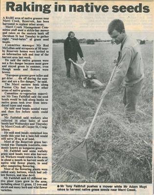
Kangaroo Grass harvesting in January 1992

Methodical knapsack spraying is critical for grassy weed control. Post-burn conditions are the most efficient for this precision work.

MCMC Team members planting.
Vegetation Quality Mapping


Vegetation Quality at Central Creek Grassland in 1994, 2004, 2006 and 2008.
The initial 1994 mapping relied on aerial photos that were then ground-truthed. Later mapping was carried out at finer detail using GPS. An apparent deterioration between 1994 and 2004 may be an artefact of this different mapping intensity but may reflect the irregular application of fire and weed control over the intervening years.
Mapping carried out in 2004 was instrumental in targeting works that have led to subsequent significant improvement. Some small reversals may be noted in quality where intensive planting has become weedy at a later stage. Such areas do recover with further care.
The impact of previous land uses can be seen in the degraded areas associated with the fencing and tee-off mounds of the former Golf Driving range in the north of the site. The highly degraded creekline, on the western side of the Reserve, is mapped but has not been subject to intensive restoration works by Merri Creek Management Committee.
In all maps, the Reserve has been shown with the current (permanent) boundaries.
Reintroduction of Species

(above) Callitriche brachycarpa- a specimen photographed in 2002, a year after planting. Habitat destruction and drought have meant that neither remnant nor planted specimens have been seen since that year. It has possibly become extinct at the Ngarri-djarrang Grassland Reserve.
(right) A successful reintroduction is the state-significant Swamp Everlasting Daisy, Xerochrysum palustre, which has persisted for several years since planted at Ngarri-djarrang Grassland Reserve in 2002.

(above) Microseris scapigera- a reintroduced specimen one year after planting in 2002. These plantings subsequently failed. This species continues to dwindle in the Merri catchment and increased efforts are underway to secure local gene pool.

Threats and Management

Despite fencing, serious dumping incidents still occur. In 2006, a landscaper disposed of excess soil on the reserve, burying native vegetation with a deep layer of compacted soil.

Sensitive hand-removal of the soil was recommended by MCMC and coordinated by Darebin City Council

Although the soil had been on the vegetation for several weeks, the vegetation survived and the need for costly revegetation was prevented.

Carefully supervised removal of redundant powerlines that crossed the reserve in 2002 was a significant sign that Njarri-djarrang was now a reserve for conservation.

Deep ruts from illegal vehicle access in winter were a common sight prior to fencing of the reserve.
Community Engagement

Planting a buffer along the north west corner of the Grassland with community in 2008

Snake handler shows are popular with locals. Reducing anxiety about snakes is an important step in helping people appreciate their local grassland reserve.

Planting with community
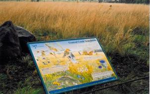
Installation of colourful interpretive signage in 2002 provided some important ‘cues of care’.

Interpretation walks with local community in the Grassland as a part of a school holiday program in 2008. Based on a small local playgroup.

Seed collection with volunteers
Fauna

(above) Pallid Cuckoos are springtime visitors to the Ngarri-djarrang Grassland Reserve, feeding on the hairy caterpillars that feed, in turn, on native grasses

Astonishingly, a small group of Eastern Grey Kangaroos have re-established in Ngarri-djarrang and persisted for several years. Their grazing has important ecological effects and their presence has been influential in improving people’s opinion of the grassland reserve.
[1] Ngarri-djarrang is the name recently given to the site by a Wurundjeri elder, Doreen Garvey-Wandin. The site is otherwise known as Central Creek or Davidson Street Grasslands.
[2] The Victorian Volcanic Plain grasslands contains a range of recognized Ecological Vegetation Classes (EVCs)
[3]Ellender, Isabel & Christiansen, Peter, 2001. People of the Merri Merri. Merri Creek Management Committee (available for purchase from MCMC).
[4] DCE (1990) Remnant Native Grasslands and Grassy Woodlands of the Melbourne Area. Department of Conservation and Environment, Victoria.
[5] Faithfull, T. & Lord, R. (1992) Re-zoning proposal and management recommendations for the Central Creek area – Reservoir, unpublished report.
[6] Robinson, R.W. & Duggan, D. (1994) Davidson Street Grassland – A report on the flora, fauna, development options and management, unpublished report.
[7] Referred to as “conservation values” at the time.
[8] Merri Creek Management Committee (1993) 1993 Projects. Reports to Parks and Waterways Program and Greening Australia Victoria. Davidson St, Reservoir.
[9] Port Phillip & Westernport Catchment Management Authority (2004) Port Phillip and Western Port Regional Catchment Strategy.
[11] The underlined names are the formal names using the Ecological Vegetation Class nomenclature widely adopted in Victoria see DSE’ EVC web page.
[12] Bush, J. & Faithfull, T. (1997) Management Guidelines for the Native Grasslands of the Merri Creek, Merri Creek Management Committee.
[13] For details of some of these activities see Making Friends for Urban Grasslands evaluation report MCMC (2007)
[14] Central Creek Environmental Awareness Kit (undated) VicUrban, Melbourne.
[15] See Bush & Faithfull (op.cit)


 Merri Creek Management Committee. 2 Lee St, East Brunswick, Victoria, Australia 3057