
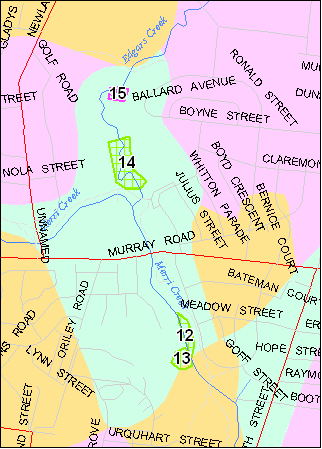
 LOCATION: YARRA 5000/04.09 E21400 N22000 to E21500 N21660
Channel and adjacent floodplain and terrace of Edgars Creek between Outlook Drive and Ronald Street, North Coburg.
ACCESS: Outlook Drive and Ronald Street, North Coburg.
OWNERSHIP & MUNICIPALITY: Public Land, City of Coburg.
SITE DESCRIPTION: The site is a broad terrace and floodplain crossed by the meandering channel of Edgars Creek. The creek is incised up to 2 metres below the level of the ten-ace which is a relict feature developed when both Merri Creek and Edgars Creek were partly blocked by the lava flows and deposited sediment in a series of lakes and swamps. Undercut bank sections show the stratigraphy of these sedimentary deposits. The floodplain was deposited when both Edgars Creek and Merri Creek were in higher level channels before Merri Creek had deeply incised into the confining lava flow.
The Edgars Creek channel is a dynamic feature and in places is undercutting the bank and extending the meanders. A natural "goose-neck" meander is forming at the site. This is a natural process and illustrates the method by which alluvium is transported and stored in stream channels.
SIGNIFICANCE RATING: LOCAL
The site is a clear example of a confined floodplain. It is the least modified remnant of a more extensive alluvial unit that extended eastward toward Elizabeth Street. This unit was the bed of a Pleistocene age lake that had been dammed by lava flows spilling into the southern end of Edgars Creek and also blocking Merri Creek. Bones of extinct marsupials including Diprotodon were found in clays of this lake deposit although these older sites are now covered by buildings. The modern floodplain of Edgars Creek is a younger geological feature than these lake deposits.
SITE SENSITIVITY, THREATS, POTENTIAL UTILISATION
CLASS 2. The creek channel is a dynamic feature and in places is undercutting the bank and extending the meanders. This is a natural process and illustrates the method by which alluvium is transported and stored in stream channels. As some sectors are now covered by rock walling, consideration should be given to allowing some meander bends to continue to erode as the undercut banks provide excellent natural cross sections of older and modern alluvium. Land use adjacent to the channel should be designed to accommodate channel changes. There are no other opportunities in the Metropolitan areas of Merri Creek and Edgars Creek to allow this process to be seen.
REFERENCES:
Hanks, W. 1934, The Tertiary sands and Older Basalt of Coburg, Pascoe Vale, and Campbellfield, Victoria. Proc. Roy. Soc. Vict., 46 Part II, 144-150.
Postscript: This site has been destroyed by creek stabilisation works by Melbourne Water.

Photograph 21. Incised goose-neck meander at Site 14.
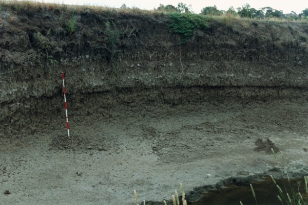
Photograph 22, Bedded alluvium at Site 14.


 Merri Creek Management Committee. 2 Lee St, East Brunswick, Victoria, Australia 3057