
Chapter 2
GEOLOGY & GEOMORPHOLOGY OF THE MERRI CREEK CATCHMENT
This Chapter contains 2 subsections:
2.3 Modifications to the Merri Creek Valley and Channel
2.1 GEOLOGY
For most of its course, Merri Creek is confined in a narrow, incised "inner" valley bordered by flat, undulating or irregular plains which are crossed by only a few small and weakly incised tributary streams. The boundary of the "inner" valley and the adjacent plain is typically well-defined by bluffs or rocky cliffs and there are several short gorge sectors at Craigieburn, Thomastown, Fawkner, Northcote and Fait-field. The report concentrates on the inner valley slopes as these comprise the main area of Public Land and open space in the Metropolitan Municipalities. In the (largely rural) Municipality of Whittlesea, the report extends beyond the inner valley to include a strip of the adjacent plain.
A variety of rocks of Palaeozoic, Tertiary and Quaternary age occur in the study area although the surface geology and the landforms are dominated by basalt lava flows of Pleistocene age. Stream valleys cut into this lava surface comprise the main elements of relief and terrain variation and provide exposure of the basalt and in places older sedimentary rocks.
The bedrock of the study area is a thick sequence of Silurian/Early Devonian argillaceous (muddy) and arenaceous (sandy) marine sediments comprising numerous beds of mudstone, shale, siltstone and sandstone. The rocks are part of a stratigraphic and structural unit known as the "Melbourne Zone" (formerly referred to as the "Melbourne Trough"). The Melbourne Zone is part of the Lachlan Fold Belt which comprises the southern unit of the major Palaeozoic geological structure of eastern Australia - the Tasman Orogenic Zone. Rocks of similar origin to those of the Melbourne Zone outcrop across Victoria forming the basis of the Victorian mountain areas. In the Melbourne Zone, the sediments are up to 10 000 metres thick. These rocks were deposited in a deep ocean basin as layers of mud (silt and clay) and sand. Many of the sedimentary layers were distributed across the sea floor by fast flowing submarine, currents (turbidity currents) which accounts for the rapid alternation of sand and muddy beds. On the, basis of order of deposition, distinctive rock sequences and fossil content, these rocks in the Merri Creek catchment are known as the Anderson Creek Formation, the Dargile Formation and the Humevale Formation. In the Melbourne metropolitan area, the term Melbourne Formation is used to describe the Dargile Formation.
After compression and cementation the sedimentary rocks were uplifted, folded into anticlines and synclines and faulted during the Late Devonian about 380 million years ago. In nearby areas, they were then intruded by small masses of granitic rocks and thinner, tabular dykes. The folds were formed by compression during uplift, with the thick, competent sandstone beds deforming often by brittle fracture, bending around and deforming the less competent mudstones. The folds in the Siluro/Devonian rocks are broad, upright anticlines and synclines with the fold axes striking NNE/SSW and spaced between 1.0 and 3 km apart. The dip of the beds is generally steep with dips of 45' to 70' being common. Stresses during folding caused a number of fractures (faults and joints) to develop in the rock. Small scale faults (with slips of up to one metre or more) are common in the Silurian rocks and around the fold axes there are zones of intense jointing.
There is excellent exposure of folded and faulted Melbourne Formation on the left bank of the Yarra River at Dights Falls opposite the confluence of the Merri Creek. Other significant outcrops of Melbourne Formation are as follows:
(a) in the Merri Creek on the right bank just upstream of the Dew arched pedestrian bridge at Sumner Park (below the SEC Brunswick Terminal Station);
(b) in two faces of the old quarry at the western end of Miller Street, Preston (by the tennis courts - an excellent section)
(c) in the bed of Edgars Creek about 300 metres upstream of the Merri Creek junction;
(e) on the right bank of Edgars Creek south of Tilley St (North Coburg/Reservoir) below the Kodak plant;
(f) In Edgars Creek between Leamington St and Broadhurst Ave, Reservoir;
(g) on the left bank of Merri Creek just below Carr St and downstream above the Coburg Lake, (not accessible);
(h) on the left bank at the ford at the "retarding basin" (Campbellfield);
(i) on the right bank of Barry Road Gorge (magnificent section overlain by basalt);
(j) in the quarries north of Craigieburn East Road (not accessible). The deposits here are deeply weathered and forms the parent material of the extensive clay deposits worked at Craigieburn. These deposits are both in situ weathering deposits and high level alluvium derived from erosion of the Silurian rocks and deposited in ancestral valleys of the Merri C reek.
Summer Hill and Woody Hill are inliers of Silurian Rock surrounded by basalt. Deep cuttings on the Woodstock - Wallan - Epping Road at Merriang near Beveridge Road give excellent exposure of rocks of the Humevale Formation (including weathered dykes).
Overlying the Silurian rocks are Tertiary volcanic (Older Volcanics) and non-marine sands and clays (Brighton Group). These have very limited outcrop as they are either buried by younger lava flows (Newer Volcanics) or have been masked in recent years by residential and industrial suburban expansion. No accessible sections are presently available apart from a weathered contact at locality (f) above in Edgars Creek and at locality (h) at Campbellfield.
The surficial geology of the study area is dominated by lava flows originating from eruption points located between Craigieburn and Wallan (Mount Ridley, Hayes Hill, Bald Hill, Mount Fraser, Springs Hill and Green Hill). These belong to the Newer Volcanic series with lava flows dated at between 4.6 million years to 0.81 million years (Page 1968). The lava spread radially from the vents filling depressions and shallow valleys and diverting and disrupting the existing streams. Individual flows were relatively thin (0.5 to 8 metres) and fast moving as indicated by the vesicular and ropy nature of many lava surfaces. Overlapping of flows has produced an overall thickness of basalt reaching 60 metres or more along the middle and lower reaches of the Merri Creek. A lava dated at 2.2 million years from Hayes Hill extended down an ancestral valley of the Merri Creek and into the Yarra River. The youngest flow in the region (dated as 800,000 years) either from Mount Fraser or Hayes Hill) followed and filled former valleys of the Merri Creek and Darebin Creek, extended south to the valley of the Yarra and thence westward along the Yarra valley to the vicinity of Spencer Street in Melbourne. The most recent volcanic events have been from Hayes Hill, Bald Hill and Mount Fraser, the latter having a final phase of scoria eruption which built the distinctive high, steep cones enclosing the two craters.
Although greatly modified by weathering, stream incision and soil development, the volcanic origin of the study area is well illustrated by the prominent volcanic cones of Mt Fraser and Bald Hill, the rough, stony surfaces of the plains and the large jointed basalt blocks of many valley-side cliffs. Fine examples of the thickness and structure of the lavas are exposed in cliffs in the Merri Creek gorge south of Rushall Station.
Alluvial materials related to the level of both the present stream and higher level streams occur more-or-less continuously along the course of the Merri Creek. All are related to the occurrence of lava flows - either diverting or damming the creek or forming knickpoints in the present channel. The extensive area of alluvium south of Wallan East is a result of blocking of the stream by the Mount Fraser/Bald Hill lavas and the formation of Hernes Swamp. Other alluvial sections downstream of major knickpoints on basalt bars occur at "Merriang Park", "Merri Park", Donnybrook, Craigieburn East, Mahoneys Road, Edgars Creek confluence and as the Northcote floodplain.
2.2 GEOMORPHOLOGY
2.2.1 ORIGIN OF THE LANDFORMS
Hills and ridges of Silurian sedimentary rock enclose the northern part of the Merri Creek catchment and form the conspicuous relief of Summer Hill and Woody Hill. These represent the oldest or residual landform units of the area as their form was largely determined before the eruption of the younger lavas. The geomorphology of the study area is largely determined by the character of the lava flows and subsequent incision of the Merri creek into the lava surface. As even the youngest flows are almost 1 million years old there has been substantial weathering of the Newer Volcanics basalts. Weathering proceeds along joint planes and in linked vesicles in the basalt so that the depth and degree of weathering is closely related to the intensity of original fracturing of the rock. Massive or impervious zones of the lava are left as inliers of intact rock Surrounded or covered by weathering residues and soil. Weathering of basalt converts the feldspathic and ferromagnesium minerals to clays and as there is no quartz in the rock, a typical basalt soil is dominated by grey or dark grey-brown clays and has a negligible sand or silt component. Isolated stones or "floaters" can occur in many weathering profiles and soils.
The present alignment of the Merri Creek has been determined by the spread of lava from Mount Fraser, Green Hill, Bald hill and Hayes Hill. These volcanoes erupted onto a landscape of low hills and valleys (including the ancestral valley of the Merri Creek and its tributaries). With the emplacement of the volcanic deposits, drainage from the northern part of the catchment was blocked and swampy alluvial plains formed north and north cast of Mount Fraser around the northern margins of the lava. As the lava surface sloped down toward the east and south from the eruption points, the post-volcanic stream channel (overflowing from the northern swamps) developed around the eastern margins of the lava and at the edge of the hillslopes of Palaeozoic rock forming the eastern edge of the catchment. The creek course was then determined by natural depressions and ridges of the lava surface and by the major fractures and joints in the volcanic rock.
The long profile (figure 2) shows the gradient of the Merri Creek from its source near Heathcote Junction to the confluence with the Yarra River. After an initially steep fall on the southern slopes of the Dividing Range, the gradient flattens across the alluvium of the (drained) Hernes Swamp formed behind lava flows from Mount Fraser and Bald Hill. Across the lava flows the long profile is irregular. Long sectors of low gradient alluvial channel end in steeper sectors where the creek is actively downcutting into basalt rock producing short reaches of rapids and riffles. In these sectors, the valley is narrow with steep valley-sides and the channel is often encumbered by large fallen blocks. Alluvium occurs almost continuously in and alongside the channel and is typically undercut and eroding in the rural areas where stock have access.
The sinuosity of the Merri Creek is relatively low (1 - 1.5) and the meander form of the channel matches that of the valley (as compared with streams which meander with a more complex pattern than the enclosing valley). In plan form, the valley has four major meander patterns - all related to the type of substrate crossed (Fig. 3). North of Beveridge Road across the alluvial flats, the channel has either straight segments or very low amplitude meanders (Fig. 3A). Across the basalt plains to Donnybrook, the valley has small, irregular meanders of low amplitude and length averaging about 50 metres (Fig. 3B). South of Summerhill Road to Mahoneys Road, the geometry changes as the stream flows over older lava at the western margin of the newer lava flows. Meanders here are symmetrical with dimensions of 150-F metres (Fig. 3C). This pattern is somewhat modified south of Mahoneys Road and the meanders become more sinuous or exaggerated as the valley narrows. South of Coburg Lake the sinuosity of the valley decreases (Fig 3D) and the once sinuous channel has been simplified by channelisation works.
The toughness of the lava has restricted valley widening. As with other streams that cross the Newer Volcanics lava fields of Victoria, the Merri Creek flows in a well-defined, narrow valley usually bounded by steep slopes and bluffs with rocky cliffs and gorge sectors. Cross profiles of the creek (Fig. 4) show the depth of vertical incision and the clear boundary of the inner valley with the adjacent lava plain. There is often a marked asymmetry of the valley profile - especially across the broader valley meanders. The floodplain is restricted in width due to the narrowing of the inner valley and this magnifies the hazard of downstream flooding. Flood mitigation works, including straightening and channelling of parts of the creek bed and building high levee banks, has reduced the incidence of flood damage to properties.
An unusual feature of the geomorphology of the Merri Creek is the "retarding basin" area south of the Barry Road gorge. The basin is an area 1 km long and up to 500 m wide and is eroded through basalt and Tertiary sedimentary rocks exposing Silurian sediments. The creek has meandered across the floor of the basin and cut well-defined valley-side bluffs on both sides. The bluff on the eastern side is a more degraded slope than the western.

Figure 2. Long profile of Merri Creek.
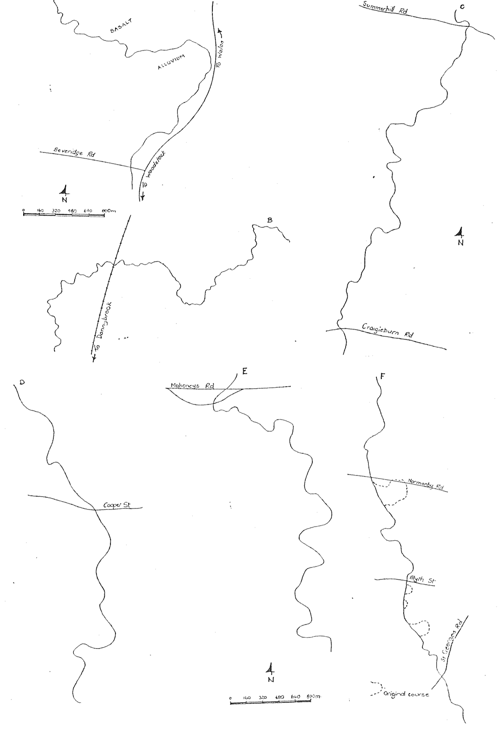
Figure 3 - Meander patterns of the Merri Creek valley-

The floor of the basin is covered by alluvium which surrounds two low flat hills, one with a small residual capping of basalt. The only remaining, natural alluvial cut-off meander in the study area is in the process of developing here. The basin has developed immediately below the major knick point of Barry Road gorge.
With a limited floodplain and a history of downcutting rather than valley widening, there is little development of alluvial terraces. There may be remnants of alluvial terraces but the valley sides are dominantly gently sloping erosional benches veneered with alluvium, slope wash and soil.
2.2.2 LANDFORM UNITS
- Hills and ridges of Silurian rock.
- Eruption points.
- Strongly undulating volcanic plain with stony rises.
- Undulating to flat volcanic plain.
- River valley cliffs and bluffs.
- Valley side slopes.
- Stream terraces (bedrock and alluvial).
- Alluvial plains.
- Modern floodplain.
- Stream channel.


 Merri Creek Management Committee. 2 Lee St, East Brunswick, Victoria, Australia 3057