
A Highly Commended Restoration Project - the example of Ngarri djarrang

 The catchment-scale restoration of Merri Creek has been selected in the 'Highly Commended - Projects with Potential for Biodiversity Research Partnerships' category in the Ecological Management and Restoration Journal’s search for the ‘Top 20’ ecological restoration projects in Australasia.
MCMC has prepared a report detailing MCMC’s Restoration of a Native Grassland community – The Ngarri djarrang (Central Creek) Grassland in Reservoir – as an example of the works we undertake.
Read more Download the report as a pdf
Uncover, Recover & Discover your Merri Creek.
The changing fortunes of Merri Creek come alive in a new series of displays that demonstrate how far we’ve come in restoring the creek. Images from Merri Creek Management Committee’s treasure trove of records contrast the different eras of the Merri corridor.
If you weren’t around twenty years ago you’ll be surprised at how much the landscape of the Merri has changed since the 1980’s. You can help play a role in its future.
The displays have also been produced as laminated flip-charts that can be seen at plantings and school visits.
The displays were produced by Merri Creek Management Committee for a Friends of Merri Creek project funded by a Federal Community Water Grant.
 | Merri Creek Robinson Reserve, PrestonMerri Creek Preston - once surrounded by majestic trees, diverse aquatic vegetation and a chorus of frog calls. It may have looked like this prior to European settlement. Actual Photo: Merri Creek at Cooper St, Epping. |
 | Craigieburn; Aitken CreekAitken Creek, Craigieburn - once surrounded by dense tussock grasslands and ancient red gums and was teeming with wildlife. It may have looked like this prior to European Settlement. Actual photo: Malcolm Creek, Craigieburn. |
 | Clifton Hill; Hall Reserve WetlandWetlands were once common throughout the Merri Creek catchment and offered habitat for scores of fish, insects, birds, lizards and frogs. Some of them may have looked like this. Actual photo: Hall Reserve wetland, Clifton Hill. |
Photo Comparisons of Merri Creek Before and After Revegetation
Clifton Hill | |
 Path under Heidleberg Road bridge, Clifton Hill 1982 | 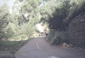 Path under Heidleberg Road bridge, Clifton Hill 1996 |
 Yarra Bend parklands, Clifton Hill 1982 |  Yarra Bend parklands, Clifton Hill 1996 |
East Brunswick | |
 Albion Street, East Brunswick 1982 |  Albion Street, East Brunswick 1999 |
 Blyth Street, East Brunswick 1982 |  Blyth Street, East Brunswick 2001 |
North Fitzroy | |
 St Georges Road bridge, North Fitzroy 1982 |  St Georges Road bridge, North Fitzroy 1996 |
 Path to St Georges Road , North Fitzroy 1982 |  Path to St Georges Road , North Fitzroy 1993 |
Preston | |
 Kendall Street footbridge, Preston 1982 |  Kendall Street footbridge, Preston 1996 |


 Merri Creek Management Committee. 2 Lee St, East Brunswick, Victoria, Australia 3057