
 An unusual feature of the geomorphology of the Merri Creek is the Galada Tamboore area (which used to be known as the Cambellfield Retarding Basin, north of Mahoneys Road.
The basin is an area 1 km long and up to 500 in wide and is eroded through basalt and Tertiary sedimentary rocks exposing Silurian sediments. The creek has meandered across the floor of the basin and cut well-defined valley-side bluffs on both sides (see Site 25 - Galada Tamboore Alluvial Basin). The bluff on the eastern side is a more degraded slope than the western. At the base of the western bluff is an unconformity between the underlying Silurian rock and Newer Volcanic basalts (see Site 26 - Galada Tamboore Unconformity). The floor of the basin is covered by alluvium which surrounds two low flat hills, one with a small residual capping of basalt. The only (remaining) natural alluvial cut-off meander in the study area is in the process of developing here. The basin has developed immediately below the major knick point of Barry Road gorge.
Dolomite outcrops at the southern end of the site on the east bank of Merri Creek (see Site 24 - Galada Tamboore Dolomite).
Silurian, basalt and dolomite nodules
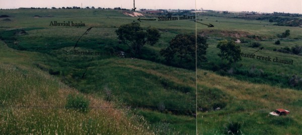
Photograph 34. Composite photograph and overlay of the alluvial basin north of Mahoneys Road (Photo Neville Rosengren approx 1993).


 Merri Creek Management Committee. 2 Lee St, East Brunswick, Victoria, Australia 3057